Sunday, August 27, 2023

Ishizuchi-san

Toyohashi Alpine Club
Mountaineering in Japan

9 September 2022
Saijo, Shikoku, Japan
Party: Darren DeRidder

Ishizuchi-san summit shrine from Tengu-dake

The end of a summer spent in Japan turned out differently than expected. Not long after I returned from my trip to the North Alps with Iain, I came down with a fever and tested positive for COVID. I'm fairly sure I picked it up in the Karasawa Hutte. By the time I fell sick, my return flight to Canada was only a week away, but I was required to self-isolate for ten days, and had to postpone my departure.  There were no affordable flights until mid-September, so my stay in Japan had to be extended by another three weeks. That was also when my visa was set to expire. It was all a huge hassle and sitting alone in a tatami room for ten days was also not at all how I wanted to finish my summer in Japan. It did give me an opportunity to mull over what I might do after I got released from quarantine, however. 

I had come to realize that in the sweltering heat of the Japanese summer, there are really only two places I want to be: at the beach or in the mountains. And after the trip up to Kamikochi for an attempted rock climb that was unfortunately stopped by bad weather, I had been struggling with a lingering feeling of disappointment at not having climbed anything noteworthy.  Iain, who by this time was back in London, suggested that I might make a trip up to Daisen, or down to one of the notable peaks in Shikoku. My old copy of Paul Hunt's "Hiking in Japan" contained an interesting write-up of Ishizuchi.  Its description of chains adorning sheer rock faces sounded intriguing, so a plan came together to go and climb it.

Leaving on a Thursday afternoon from Himeji I took the Sanyo Shinkansen line to Okayama and transferred to a slower train on the Seto-Ohashi line over the impressive series of bridges that also carry the Seto Chuo Expressway, island-hopping all the way from Kansai to Shikoku and onward to Saijo city. 

View from the Seto Bridge

It was dark by the time I got to Saijo, but the hotel where I had a reservation was mere steps away from the station, so it didn't take long to get checked in.  It was after 7pm and a lot of restaurants were already closed, but I came across a casual and trendy looking pub on the main street in front of the station that stayed open late and specialized in Okonomiyaki. I asked for the chef to choose one of the more popular dishes for me, ordered a beer, and enjoyed a really good meal before heading back the hotel and taking a soak in their hot spring bath. 

I didn't get a particularly good night's sleep, but was up early to make a quick stop at the convenience store before heading back to the station to get a ticket for the bus that would take me up to the Ishizuchi ropeway. With some time to spare before the bus arrived I took a short stroll around the station area and admired the buildings and views of faraway peaks from a vantage point nearby. In the early morning, Saijo seemed like a pretty if not particularly exciting town.

Views near Saijo Station

The bus stop in front of the station wasn't hard to identify since there was already a small gathering of hikers in the shelter, who sat in silence and pretended they didn't notice one another. With a few minutes before the bus was scheduled to arrive, I made one last run over to a nearby drink vendor to get a bottled drink. When I got back, a bus was pulling away but the group of hikers was still sitting in the shelter. Amongst the group were a young fellow in typical street wear, and older gentleman in blue jeans, and like the proverbial rose among thorns, a young lady who was the only one that looked properly dressed for the occasion in proper outdoor gear. The scheduled bus time came and went, and I began to worry that I'd missed my ride, but after a few more minutes the bus to Ishizushi Ropeway came rolling into the terminal area and we all got on board. Winding our way through the town we soon got up into the forested hills and followed a precipitous course along a river valley with impressive views and the odd section of road work, were construction crews were busy shoring up the near-vertical slopes. It looked like dangerous work. Along the way we passed under a house that was clinging to the hillside above the road, and the driver slowed to call out to an old man who was leaning out the window, waving.  A couple of sentences were shouted back and forth, with smiles and waves; in such an isolated location I suppose the passing bus was a highlight of the day for the old fellow. 


The lower end of the route was the ropeway station, or more precisely, a hovel of roadside shacks leading to a decrepit covered stairway with a very rusty sign over it declaring the entrance to the ropeway. I had hoped to fill my water bottles here at the base of the ropeway, and although running water was present, the staff at the ropeway station said it wasn't drinkable. I'm not entirely sure about that, as most tap-water in Japan is potable and I've never gotten sick drinking from mountain streams there either. I decided to see if I could find a water source at the top end of the ropeway. In the worst case, I understood that there were a few huts along the way where drinks could be purchased.  The number of hikers waiting to take the ropeway up had grown beyond the group who had arrived by bus. They included a few folks in flashy running gear. 


The ropeway took us quickly up the mountainside, climbing ever more steeply the higher we got. Normally, the idea of taking a ropeway to get partway up a mountain wouldn't appeal to me, but in this case, it avoided hours of what could only be a monotonous, soul-destroying slog up an unforgivingly steep and densely forested slope, and it was the only way to get the route done in one day as a round trip from Saijo. The interesting climbing would begin once we got up out of the deep valley.

At top of the ropeway was a small building with some washrooms, a small shop and a couple of vending machines, and this led out after a short walk to a collection of buildings with little shops and such, which in the busy season are probably in full swing, but appeared to be mostly shut down as I wandered through. I took the opportunity to get a couple of bottled drinks from a vending machine and organize my gear a little before setting off onto the trail, which led through a large shrine gate and, much to my dismay, downwards.


The trail carried on downwards for a good ways, and I started thinking that not only would I have to make up this lost elevation on the way to the summit, but I'd have to be climbing back up this hill on the final stretch of the return trip as well.

I was feeling eager to put some distance under my boots and had pushed ahead of most of the other climbers, which was somewhat pointless considering that the slower-moving hikers always tend to be more consistent and end up arriving at the destination within a few minutes of the speed-hikers anyway.  Sure enough I got overheated enough that I needed to stop for a couple of minutes, and was passed by a few of the stronger hikers.  Later on I again caught up with a couple of them, including the young lady who looked like the most experienced climber, and we exchanged a bit of small talk before each pushing onwards. The trail got fairly steep and had many sections of crude steps fashioned from tree branches rough-hewn timbers wired together, many of which were collapsed and had to be carefully navigated.

The trail seemed to be pretty wet but true to the guidebook there wasn't any fresh running water to be found along the way. Pressing on I came to a section where large iron "kusari" chains were hanging down a steep rocky section, which the regular hiking trail bypassed on the left.  These were the "practice chains" which, it is said, are a suitable test for one's ability to complete the three subsequent sets of chains which are the "real deal".  I didn't particularly want to expend my energy on the practice chains, preferring to save my strength for the longer more challenging sections ahead.  Later on, I learned that this initial set of chains isn't meant for practice so much as it is as a test to see whether or not you've got what it takes to do the other three sets of chains, and as such, they're quite challenging in their own right.
Somewhere after this a rather steep set of steps led up to a col where a very decrepit old hut was sitting, manned by an old guy who seemed to be mostly ignoring people passing by. There were some drinks for sale, and I took a mental note of that in case on the way back I needed to rehydrate, as the drinks I had purchased lower down were already running low. Following the ridge, the trail emerged out into an flat section of low bamboo grass which provided views in all directions, but unfortunately the clouds obscured what would have otherwise been a spectacular vista.


Although it seemed from the bamboo plateau that there wasn't much higher to go, behind the clouds ahead the true summit of Ishizuchi was hidden in mist, and the real challenges of the climb were about to arrive. There were three sections of near vertical rock down which were hanging these enormous kusari chains. The rock itself provided plenty of footholds in most cases, but in some areas, triangular links like "aiders" had been forged onto the kusari as footholds. The chains themselves were quite polished and didn't provide the most secure feeling.  It took some determination to get into the right headspace going up.  One of my fellow climbers, who I had started chatting with earlier, led the way and paused to see how I was doing on one of the more difficult sections.  Seeing that folks were looking out for one another gave me the encouragement I needed to batman my way up the rest of the chains.  Two more sections of chains followed, each longer than the previous, with the final set being nearly 70 meters long.

On the day I climbed Ishizuchi, there were only a couple of folks ahead of me on the chains, and spread out so far that I suppose they reached the end of the chains just as I was beginning them.  On a busy day, these chains are reported to be jammed full of people, head to toe, and could be a real train wreck if a single person were to slip and fall, taking everyone else with them.  Nevertheless, apparently folks of all ages including kids can be seen scrambling up this mountain during the height of the climbing season.


The last set of chains deposited me near the final summit ridge leading up broad stone steps past a mountain shelter to the shrine at the top of Mt. Ishizuchi.  Here there was a broad flat area where a lot of climbers were sitting down to have lunch and take in the views.  Between the clouds you could catch glimpses of mountain ridge lines leading off into the distance, bits of blue sky and sea.


The highest peak of Ishizuchi is Tengu-dake, a short scramble further along the ridge. Prior to climbing, I had been studying the map and gotten the mistaken impression that Tengu-dake might be a little too far to include in a one-day round trip climb from Saijo and back, but I asked some of the other climbers how long it took to cross over and they said it only took about 15 minutes.  After a short break, I decided to head over, and the young lady with the good climbing gear said she would go as well, so we headed over together.  There were a couple of bits that required good balance and steady footing, where I crouched down and scampered across while uttering a mild oath... just enough exposure to keep things interesting.


And then finally I was at the summit of Ishizuchi.  Photos were taken, and although the views were mostly obscured by clouds, one side of the mountain had some clear air and view, and looking back across to the Ishizuchi-san shrine the view was really picturesque.  Small figures could be seen picking their way along the ridge towards us as we headed back.


On the way back down, the sections of chains can thankfully be bypassed by some very robust sections of aluminum scaffold and stairs, and my defacto climbing partner, who turned out to be from Taiwan, kept me company for most of the way down.  She had memorized the ropeway and bus timetable for the trip back to Saijo, where we both were headed, so we chatted most of the back to the ropeway station and I got to hear about various mountains of the Nihon Hyakumeizon that she had climbed or was planning to.  The trip back home was long but uneventful, and I was really glad to have climbed something before the end of my extended Japan stay.  Ishizuchi was actually a lot of fun - not a high mountain, but challenging and with an interesting character.  It helped me to appreciate that there are mountains not in the 3000 meter plus category that nevertheless are very enjoyable to climb, and that plenty of good climbing opportunities exist without having to go all the way to the Kita or Minami Alps. The idea of sorting out other future objectives based on the "100 Famous Mountains of Japan" book started to take shape, and luckily for me, when I arrived back in Canada a couple of days later, a copy of that book was waiting for me in the mailbox.  Iain had kindly sent me a copy, and it provided excellent reading through the cold Canadian winter, firing my imagination for future sunny days in the mountains of Japan.


Thursday, August 11, 2022

Hike to Karasawa

Toyohashi Alpine Club
Mountaineering in Japan

Karasawa Cirque

August 9, 2022
North Alps, Japan
Party: Darren DeRidder, Iain Williams
Report by: Darren DeRidder


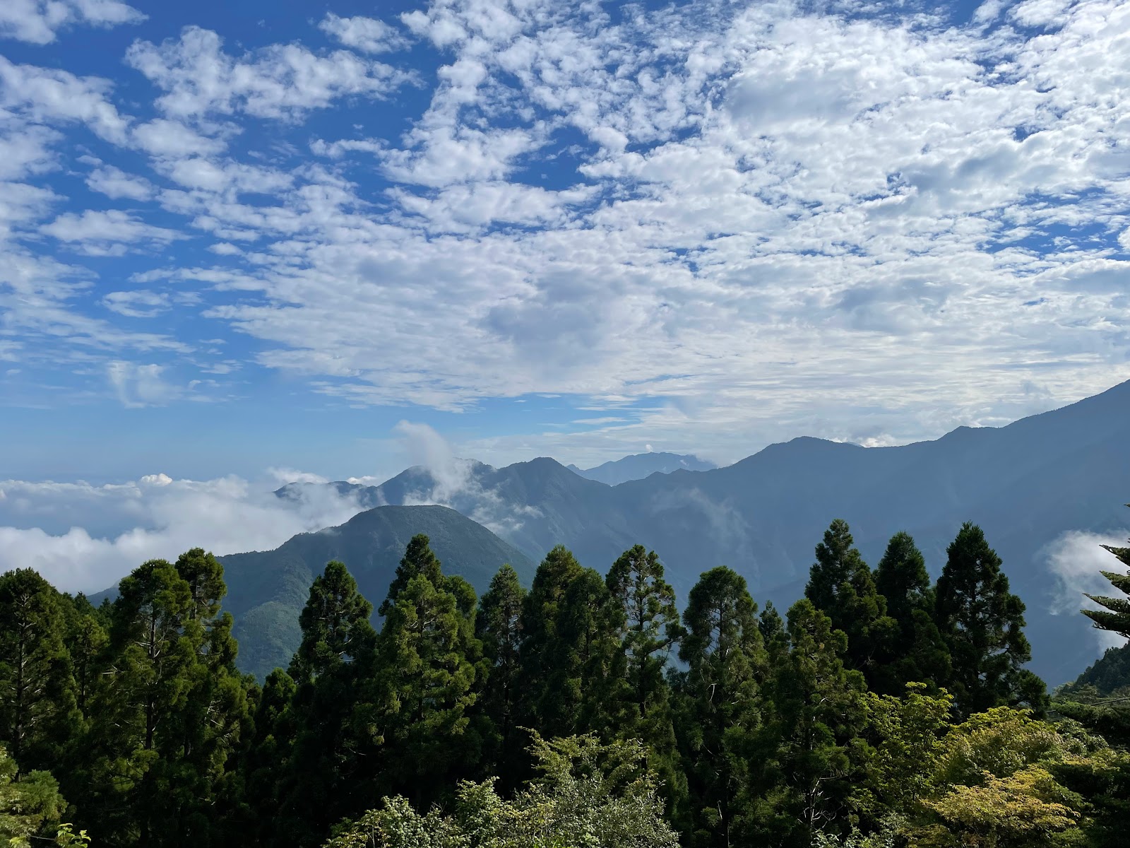
Karasawa Cirque looking towards Kita-hotaka-dake

"I wonder if that's the last time I will see that view", said Iain behind me. Turning around, I saw Kappabashi bridge, the Azusa river and the walls of Mt. Myojin rising up into the clouds. It really is a beautiful view. The gateway to the North Alps; starting point of so many good memories.  "Nope", I replied, "Sorry, but you've got to come back and finish that route!"

This was the second time we'd tried to climb the north ridge of Maehotaka-daka and been put off by the weather, and I'd like to think that we'll eventually be able to tick that route off our list.  But Iain's question caught me off guard, a little.  It's hard to believe, but it's been nearly 30 years (thirty years!) since I first came here, and back then I didn't think about a "last time" for anything. Now decades later that perspective has changed.  Who knows if, or when, we'll be back. I certainly hope we'll get back here again, both of us, and climb our route or something similar to it. The Kita Alps are one of my all-time favourite places in Japan, and simply being there and getting the old hiking legs back into action rekindled a love for being in the mountains that has been laying dormant for several years as family and other activities took precedence over climbing trips. I might not climb at the same level, with the same speed, or with the same level of risk that I used to in my 20's, but there's an awful lot of great climbing at moderate grades still to be done. And who am I kidding, I only ever climbed relatively safe and moderate climbs anyway.

This trip came together somewhat unexpectedly when I got the news, just the day before leaving for a two-month trip to Japan, that Iain had decided to go to Japan as well for 2 week in August. When he realized that his trip coincided with the O-Bon holidays we decided to go as early as possible after his arrival up to the North Alps to try and beat the rush. Scheduling required juggling some work responsibilities on my part, because of an "on-call" schedule, which has never been part of any previous software engineering job I have done, and which I have decided I really don't like and won't be part of any future job.

After meeting with our families in Kyoto on Sunday (7th August 2022), and spending a very hot day walking around some of the tourist areas, on Monday Iain and I took the Shinkansen to Nagoya and then the Tokaido/Takayama line up to Takayama, enjoying views along the way. Once in Takayama we dropped our luggage at the hotel, a new and impressive facility conveniently located right next to the station, and then spent an afternoon wandering around an old and very picturesque part of the town, although like everywhere else in Japan this summer, it was awfully hot.  My hiking boots were uncomfortable in the heat and I quickly saw the wisdom of Iain's sandals, so we found a small climbing shop (Kong) and had a look around, but I failed to find any sandals in my size. I would just have to endure hot feet and appreciate not having to carry the extra weight of boots in my pack.

The hotel in Takayama gave us a good jumping off point to be able to get to Kamikochi and hike up to the Karasawa cirque in a day, from where we planned to climb the north ridge of Maehotaka-dake.  We left Takayama on the bus to Hirayu Onsen about 9:30 AM -- a bit late but it got us to Kamikochi around 11:30 AM which we thought was plenty of time.  

But en-route to Hirayu-onsen
Kamikochi bus terminal

We did a last-minute gear-sort on the picnic tables next to the Visitor Center in Kamikochi, and I grabbed some fresh water from the faucets there. I took a quick peek inside as well, where I once again saw the bulletin board featuring the "10 Highest Mountains" in Japan which lists one peak that is not in the "Hiking in Japan" guidebook by Paul Hunt.  It lists Mt. Obami somewhere near the bottom of the list, but it seems highly debatable as to whether this peak really qualifies as a mountain on its own, or is just a subsidiary peak. It is essentially just one of the bumps along the ridge below the summit of Yari-ga-take.

Notice board in the Kamikochi Visitors Center
Gearing up in Kamikochi
The Kamikochi trail-head
Myojin peak en-route from Kamikochi

It was a bit of a dilemma whether to take my new trekking poles; I didn't want them to get in the way during technical climbing sections, but I also knew I'd be happy for them if we descended down the steep Dakesawa route. In the end I decided to leave them behind to cut down on the amount of stuff. For climbing gear we had our harnesses, helmets, a selection of slings in the 160cm - 240cm range for belays plus a few smaller ones, a couple of prussik cords, about 8 quick-draws (including a few "alpine" draws with extendable slings), Iain's 8mm 60M rope, a set of nuts, a Friend in the commonly-used #3 size range, a couple of large-ish hexes, belay devices and a couple of locking carabiners each. 

After leaving a couple of bags at the luggage storage counter and depositing our "trekking itinerary" form at the Technical Information desk in the visitor's centre, we were off, departing Kamikochi at right around noon. Incidentally, these trekking itinerary forms are now legally required by Nagano prefecture police, and you can get fined for not doing them. Most people apparently submit them online using a website called Compass, but I couldn't figure out how to use the web application which was in Japanese.  The paper form was in both English and Japanese and simply asks where you plan to go, and whether you have the essentials with you. The old gentleman at the Technical Information desk where I handed in the itinerary was delighted to meet a foreigner who could speak Japanese (albeit far from perfectly), and he was even more impressed that I had filled out the hiking form. He saw that we had a rope and was quite excited when he heard our plans to climb Maeho's north ridge, giving us a big thumbs up.

It was refreshingly cool in Kamikochi, and the fresh breeze as we walked along the wide easy trail beside the river was heavenly after weeks spent sweltering on the Kansai plains.  We soon passed Myojinkan, the climbers hostel where I had stayed a couple of times before. Not long after that we passed by the turn-off to Tokugo-toge Pass, which Iain reminded me was once a high mountain pass that cattle were taken over in the summer and brought down to our current location to graze in the riverside meadows. I believe this bit of information is something Iain got from reading early accounts of the area by Walter Weston and other early British visitors to the area, in the excellent library of the Alpine Club in London (by which I mean "the" Alpine Club, the original, British, hard-to-get-into one). This was also the route that Iain and I had decided to climb back in 2011 when we had come here with the same goal of climbing the North Ridge on Maehotaka-dake only to find the weather to be cloudy and drizzling.  On that trip we had slogged up to the Tokugo-toge pass where we stayed in a small climbers hut and were rewarded with a meal of steak, prawns, and beer as part of a work-party celebration that was going on when we got there. I can't believe it's taken us this long to come back here (11 years). Life happens; I have a lovely daughter who means more to me than all the mountains put together, and taking a break from mountain climbing to be the family man has been worth it.

Junction to Tokugo-toge Pass
Signs warning of land-slides on the Tokugo-toge trail

We made good time all the way to Tokusawa-en, arriving at 1:20pm. There we stopped for some lunch and a soft ice cream cone and I took the rope from Iain. At this point I discovered I had left an onigiri (rice ball) in my stored luggage back in Kamikochi, as well as Iain's coffee satchets, much to his chagrin.  I had plenty of other food with me in the form of calorie bars, chocolate etc. so I was more concerned about the rice ball making my stuff in storage smell bad. 

Easy trail to along the Azusa river
Tokusawa hut

Leaving Tokusawa at 1:55pm, we wanted to take the Panorama Route over to Karasawa but when we arrived at the turn-off it was blocked off with a sign in Japanese that seemed to indicate the route was closed. Knowing that Japanese people tend to be pretty rigid about things being closed for sometimes strange reasons, we debated going anyway, but the trail was indeed looking a bit overgrown so we headed back across the bridge where we'd come from and continued up towards Yoko Sanso.  The trail in this area was bifurcated and quite oddly had a large section where land-works were being constructed with heavy machinery. Walking along a gravel bar I stopped and chatted with a girl who had the look of a local and was coming from the other direction, and asked about the Panorama Course. She mentioned something about it being closed due to snow, which I found very strange and not at all believable, because snow simply does not persist through August at those elevations.

We kept the pace going pretty well, chatting occasionally and stopping once when a troupe of monkeys gathered on the path ahead of us. They weren't at all interested in us as we strolled past. It was the first time I had seen Japanese Macaque monkeys so close, and I found it fascinating and a little scary to pass by so close to them.

Crossing to find the Panorama Route (closed)
Monkeys on the trail
Yokoo-sanso

We arrived at Yoko Sanso at 2:24pm and carried on across a bridge and began the long ascent up into the Karasawa Cirque. Anyone who has hiked up to Karasawa this way knows that the path gets increasingly steeper as the elevation gets higher. The last kilometer or two up the hut are a lot like climbing an unrelenting stairway and with a pack on it becomes a mind-numbing slog. Around 3:35pm about half-way along the slog up this valley we crossed another wire suspension bridge where we took a few photos before shouldering our packs for the final push up to the hut. Iain began saying at this point that he didn't think we would make the hut by 5pm, a statement which caused me some concern as I had been told we needed to check in by 4pm in less than half an hour.  I determined to push on thinking we'll get there when we get there.  I didn't even dare look up at the path ahead because it was too depressing, so I put my head down and just kept putting one foot in front of the other. At around 4:30pm I made it to a signposted gully called "S Gully". I passed one or two others on their way up to the hut, glad not to be the only straggler.

Mountain walls en-route to Karasawa
Last bridge before the final push
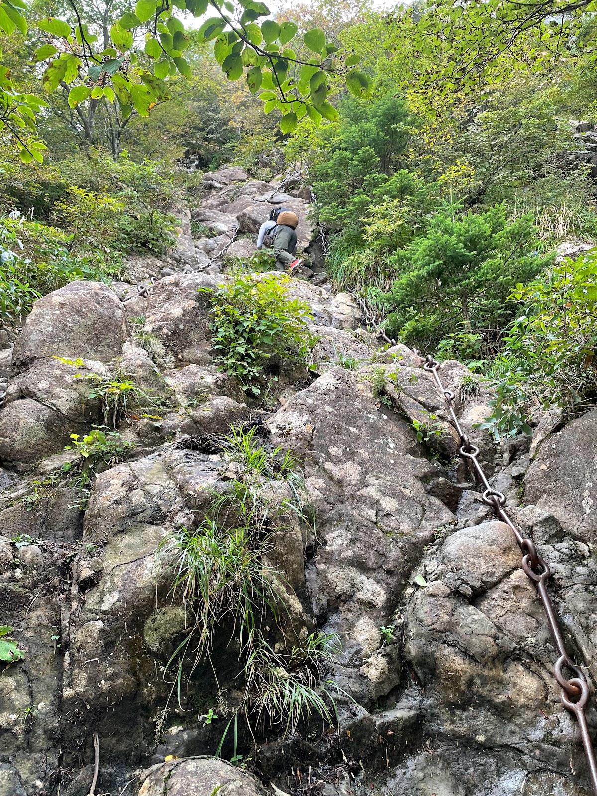
Steep trail up to Karasawa
The "S Gully"

Eventually, I heard conversation from above, climbed the final steep steps on the trail and made it up to the Karasawa Hyutte at 5:07pm where I quickly checked in.  Iain followed shortly after, having paused for a moment where the tail splits, going one way to the Karasawa Goya (hut) and the other to Karasawa Hyutte (also hut), both separated by a boulder-strewn camping area in between.  He guessed correctly that we were in the Hyutte.  We completed the hike up to Karasawa in the 5 to 5-1/2 hour range against a "map time" of 6 hours and 10 minutes. I had beaten the map time by a good hour despite our detour to the (closed) Panorama Route trailhead. If it wasn't for that detour I probably could have made the hike in about 4 and a half hours. Not carrying camping gear certainly helped. The size of some of the packs I saw on the trail looked truly agonizing. We had no intention of lugging camping gear and supplies on this climb; I think those days might be behind me. I'm sure there are people who carry a tent, stove, climbing gear and everything else with them, and climb the north ridge of Maehotakadake with all of that weight strapped to their backs, but I didn't intend to be one of them.

Karasawa Hyutte
Iain arriving at Karasawa Hyutte

It turns out that when we had not shown up by 4pm the hut called the number on file, which reached my wife in Himeji. A couple of hours previously we had been at Tokusawa eating soft ice cream, and I had sent her a picture of myself since the lodge conveniently provided a hotspot of cellular data access. My wife told the hut people we had been at Tokusawa earlier that afternoon and were on our way, to which they replied we must be close and they would wait for us. Incidentally, for my trip in Japan I used an eSim to get affordable local cellular data access, which is extremely affordable compared to the exorbitant data-roaming charges my Canadian cellular provider wants to charge. In fact, I disabled my Canadian cellular data line on my phone after getting one or two $15 roaming charges when a few kilobytes of data somehow, despite me disabling roaming settings, leaked out onto the roaming network instead of over the new eSim connection I had installed. Incidentally the eSim provider I used is Ubigi, and I have nothing but good things to say about them. It's been a lifesaver here and so much more convenient than carrying around a portable wifi hotspot.

We were at the "hyutte" well in time for dinner, which turned out to be a very nice meal considering our remote location. An Italian guy was working at the hut, and gave us a bit of information about our intended route. At dinner we had some great views across the valley, and Iain, peak-spotter extraordinaire, was able to identify some of them, which I think duly impressed our table mates. However, I think we may have not impressed them by jumping into the front of the queue when the second seating of dinner was called for. This was partly due to the fact that Iain had sat down at the top of the stairs leading into the dining room and we hadn't really noticed a well-defined queue, and partly because when they called for dinner "number 2" I thought they were referring to our hut booking reservation number, which also happened to be "number 2".  I also didn't incur too many favours by needing to get up in the middle of dinner to go talk to the hut staff about our bento-box breakfasts, which we had decided we didn't want as much as a proper sit-down morning breakfast in the morning. But Japanese people are gracious, and at such times I like to think that I can play the "ignorant foreigner" card. The folks sitting next to us did engage in a bit of conversation, asking if I had climbed many other mountains in Japan. Getting a bit over-zealous I chuckled and said its been 25 years since I first climbed in these mountains, musing about how long its been and waxing on about climbing "all" of the 3000er's in Japan -- which I realize in hindsight is not true; between the two of us we've done many if not most, but not all of them -- and I probably sounded boastful.  I'll try to do better next time.

Dinner at the Hyutte

After dinner there was not much to do, so after a bit of a wander outside to do some stretching, and brushing of teeth, I hung out in the foyer for a little bit checking out the weather forecast, which seemed to indicate similar conditions the following day (cloud cover, potential for rain or thunderstorms). Not ideal. At the front desk I inquired once again about the Panorama Course and got some vague response about it being closed due to danger. Overhearing the conversation, a Japanese man interjected that it was frozen, and we definitely could not pass it unless we had ice axes and crampons. I found this assertion annoying and ridiculous. Japan doesn't have any glaciers, and the few permanent snowfields it has, like the one higher up in Karasawa cirque, are small and easily bypassed in the hot summer. With temperatures at our elevation well above freezing at night, there was no possible way that snow or ice could be the reason for the closure. I assumed it must be because of bear sightings or a landslide, but the Japanese bloke's assertion that it was frozen and required crampons and ice axes somehow really irritated me. It seems to happen more frequently in Japan than elsewhere that you get these know-it-all types who don't really know what they're talking about but loudly pronounce the impossibility of doing something without having all sorts of unnecessary equipment.

The Hotaka ridge seen from Karasawa Hyutte

The accommodation at the hut was better than expected. I thought it would be one large room with a bunch of futons laid out but in fact it was essentially a warren of little bunkies separated by walls with curtains for privacy from the main hallway.  It was a quirky little place that had obviously seen a lot of climbers through it. All the the walls, hallways, and floors were slightly askew, and yet polished with age and the passing of many stockinged feet. It had the appearance of a building that had been there for a very, very long time and was gracefully aging and settling into the contours of the mountain. I loved the vibe.

Sleeping quarters in Karasawa Hytte
Sleeping quarters in Karasawa Hyutte
Boot room at Karasawa Hyutte

Unfortunately, although the night was peaceful, neither Iain or I were able to sleep. For Iain, it was probably jet lag, still being on London time. But for me, I guess my mind was just too active. Excited to be back in the North Alps of Japan, in a mountain hut. Concerned about what the morning would bring and how we would do on the route. With the small window in our sleeping cubicle open, a breeze wafted from somewhere within the hut, flapping the curtain separating our room from the hallway, and blowing past my face before escaping out our window. A few days later I came down with Covid and wondered if it was because of staying in the hut.

As dawn approached I may have dozed off for short stretches, only to grow uncomfortable and turn over in my futon, which was cozy although the thinly carpeted wooden floor was hard. Eventually traces of dawn leaked in through the window, a blueish grey faint light and the quiet sound of moving expanses of air punctuated with the occasional sound of activity from the earliest risers getting off to an alpine start. 

That was not for us. We got up for the second sitting of breakfast, which was still early enough. Iain seemed to be of the opinion that our route was easily climbable in a few hours with only 700M of elevation gain, albeit quite a few ups and downs along the way. Essentially a low-grade scramble with one or two pitches of easy rock climbing. I think under ideal conditions that might be the case. Stepping outside and seeing cloud and mist engulfing the entire route, I had my doubts. When a light rain began to fall I felt that it probably wasn't a good idea.  We talked again to the Italian staff member at breakfast, and asked for his thoughts about attempting the route. Obviously he didn't want to tell us wether we should or shouldn't do it, he just said he thought it was possible, but would likely be windy and cold, and the rock wet, and that a few days earlier, a party had gone up in similar weather, one of them had fallen, and staff from the hut had to form a rescue party to go up.  He offered that as an alternative, since we were planning to stay at the Hotaka-dake Sanso hut that night anyway, maybe we could just hike up there, drop off any unnecessary gear, and make a foray along the ridge to the Gendarme, which he said was one of his favourites.  Honestly, I did not like the sound of doing exposed scrambling and climbing on wet rock in cold and windy conditions, and this alternative plan seemed ok as a fallback plan, but after agonizing over the decision, Iain said he preferred to go down, which was also fine with me.  If we climbed up into the clouds there would be no views to enjoy anyway. The scheduling worked out well for me to, if I could make it all the way back to Himeji that day, which I did.

Ironically as we stood viewing the approach to the cloudy north ridge we saw a couple of climbers crossing the scree field and making their way up to the 5-6 Col.  They were going for it… But we had made up our minds.

On the way back, I sped down the trail, almost trail-running in some sections, passing numerous parties. They invariably would pause to let me pass when they heard my footsteps approaching. I said "excuse me", "thank you" and carried on, sometimes picking up bits of commentary about what long legs the foreigner had. I didn't want to appear to be showing off, but honestly I was just having a lot of fun coming down. My knees seemed to be tolerating it well, and I wanted to see if I could beat the map time by a good amount. Probably because of the running I'd been doing, my legs didn't get tired, it was more of a cardio workout. In the end, after blasting down the trail, I think I shaved only about 40 minutes off the 5hr10m map time, and ended up taking a 1.5 hour break at Tokusawa anyway, where I had an ice cream cone, waited for Iain, and then had another ice cream cone.

Back in Kamikochi that afternoon I met the old genteman from the Technical Information desk again and asked him about the Panorama Course, which he had said would be an excellent way to go. I explained that we had found both the start of the route, and the top up in Karasawa, barricaded with signs, and that someone had told me its because there was snow and ice on the route. He said he really did not believe it was closed due to snow and ice, but that it might be due to rockfall, a statement which made me feel a lot better and justified in taking a dim view of the loud-mouthed Japanese guy in the hut.

Of course I was disappointed at not being able to climb our route, and the disappointment hung onto me like the clouds that hung around the high peaks. I remained in a somber mood for several days after. But I loved being able to do this trip. I loved going back to Kamikochi, the magnificent views on bus journey there, the sorting of gear in the plaza at the Kamikochi bus terminal, the fresh mountain water and cool air, the hike in to Karasawa, the Hyutte, the mountain views, and the planning and preparation and anticipation that preceded it all.  It's all kind of bittersweet. The questionable nature of our decision not to go for it made me doubt myself and feel a bit guilty. If another party climbed it that day, we probably could have, too (but whether we would have enjoyed it or not is another question). Cancelling our planned stay at the Hotaka Sanso hut on the second night, and wondering what conditions might've been like if we'd scrambled out to the Gendarme weighed on my mind al well. And certainly mixed with these thoughts was the realization that such opportunities are rare, when members of the Toyohashi Alpine Club manage to get together and climb something, especially in Japan, wondering if and when the next opportunity will be. And realizing that now, nearly thirty years after my first visit, it's actually a good question to wonder if its the last time I'll see the view of Kappabashi… this question also joined the melancholic train of thoughts running through my mind.  It was some consolation to see on the mountain web-cams that the ridge up on Hotaka never did clear up that day, and the weather forecast for the rest of the week was even worse. At least our timing was not to blame.

Near Kappabashi bridge in Kamikochi

It was fun to hear Iain reminisce about his activities over the past years. He's an experienced traveller and a seasoned travelling companion, highly motivated to get out and do things.  Since our first years of living in the Nagoya / Toyohashi area, he's been back to Japan more times than I, and on each visit he made a point of "doing something in the mountains".  The fact that his daughters are older than mine and he was making yearly summer trips to Japan during their childhood years probably has something to do with maintaining his connection and familiarity with the mountains here. He remembered a lot of historical, cultural and geographic details which, to me, seemed like distant memories slowly re-awakening. I definitely must not wait another 10 years to go back to the Japan Alps, and I vow not to let that happen. This trip truly reminded me how wonderful it is to climb mountains in Japan, and it re-ignited my desire to do more. The seeds of planning the next trip have already been planted, so I hope that the next time I write about the North Alps, I can report that we finally climbed our route.

Thursday, July 4, 2013

Haddo Peak (3070m), Canadian Rockies

Toyohashi Alpine Club
Mountaineering in the Canadian Rockies

Hado Peak (3070m)

Banff National Park, Canada
Party: Darren DeRidder, Dwight Yachuk, Markus Sanchez, André Fink
Report by: Darren DeRidder


I just posted an old photo of Moraine Lake on my blog and it reminded me of a trip some friends and I made to Lake Louise a few years ago. Five of us rented a van and spent a week trundling up and down the icefields parkway, climbing various peaks and frequently turning around before reaching the top. Back in Lake Louise we were sitting around Bill Peyto's Cafe and thinking what we might get up to, and one of us suggested Haddo Peak. It was supposed to be really easy, and we were looking for something fun and relaxing to do, a nice day out in the mountains. The guidebook called it an ideal route for beginners, straightforward, etc. etc. The descent over the far side into Paradise Valley was supposed to be a breeze, and a nice pleasant hike out. Sounded perfect.

We started out at dawn from the Lake Louise parking lot and hiked up towards Saddleback pass. Early in the morning we angled up to Fairview Mountain and ended up on the summit just by following the trail. We hadn't really meant to go all the way to the top, so we had to drop down the ridge and cut over into Surprise Valley. It put us a little behind schedule, but the views were nice. It took a while to pick our way up Surprise Valley to the glacier. From the foot of the glacier it was supposed to be a straight easy climb up. It wasn't, really. The glacier has receded a lot over the years, and sections of it are now very steep. It was bare ice when we climbed it. We only had about four ice screws between four of us, so we picked our way up pretty slowly, my friend Dwight on lead. We anchored off our ice axes and a screw, sending the rest of the gear up on the next lead. We had to pitch it out; under the conditions the route was a bit technical.

On the second last pitch we found ourselves on a thin slab of ice with lots of water running underneath. We anchored at the top of the ice sheet by shoving a picket between the rock and the ice. The rock was totally rotten, crumbling to the touch. It would have been nice to leave the ice and get on solid rock, but that broken limestone would have been suicidal. The last pitch was basically vertical ice, and we climbed with classic alpine axes. Fortunately Dwight led it solidly (I think he borrowed a small second ice axe from one of us) and the rest of us made it with a bit of encouragement (ie. pulling on the rope). 

The time had just flown and after ticking off the summit of Haddo Peak we decided against bagging Aberdeen as well, even though it was just over the col a couple hundred meters. We still had to get down! There was a really steep scree slope that dropped off into nothingness below us. Supposedly you can "drop down from almost anywhere along the ridge" but I've since learned that there've been a number of fatal accidents involving people who took that advice. The proper descent is over the back of Aberdeen, further up Paradise Valley (or so I have read). We picked our way down from the ridge anyhow, towards cliff bands and the valley below.

It was very slow, meticulous down-climbing. Some of us were more comfortable than others with it. As long as I could see where I was going, I felt okay. Sliding down a scree slope towards a drop off, hoping you can stop if you have to, is a little unnerving though. Fortunately the scree runout funnelled us into a chimney that we could down-climb, and a traverse ended up at some slings... an obvious rappel station. We took the rappel, but our rope didn't reach the bottom. Markus had a short 15 meter piece of rope in his pack, so with that, he extended the rap and we all made it down after passing the knot with difficulty.

It was well into evening by the time we got past all the down-climbing. Once we got to non-technical terrain we still had a lot of descending to do. It just seemed to go on forever, steeply descending the alpine slopes above Paradise Valley. Night fell around us as we plodded down and down with knee-jarring steps. Out in front, I stumbled onto the trail, a line of brownish sand faintly visible against the scrub brush and grass. Now we only had to hike out on the trail, or so we thought. We needed to get back to our van at Lake Louise, and I knew we needed to cut over Saddleback Pass to get there. The fork in the trail was a long time coming. After many kilometres of walking in the dark, we found it and cut off towards Lake Louise. The trail climbed up steeply for a long way through densely wooded ravines. We kept going up and up in the dark, getting very thirsty. Our headlamps were dim circles of light that picked up the occasional fallen tree across the trail. I was confident in our position but at some point, everyone else mutinied. We had a group huddle and the consensus was to turn around and go back. The others felt we were just climbing back up into the mountains where we didn't want to go. We'd already climbed up from Paradise Valley for almost two hours, and I was sure we were approaching Saddleback Pass, which would then be a quick hike down to the parking lot at Lake Louise. But I was voted down, so we all turned around. 

At that point it all turned into a death march. We were truly worn out, dehydrated, wobbling around on sore legs and feeling miserable. All of us went into survival mode and stumbled on in silence. We stuck together though... there were warning signs for grizzly bears all over the place. A few hours later we found ourselves at the Paradise Valley trailhead along the Moraine Lake road, where we laid down for a while. Then we took to the road and walked four abreast straight down the middle of it, into the night. 

I thought I recalled this road being 13km long. Getting to Lake Louise along this road would take forever. There was nothing to do but keep walking. Behind us the lights of a vehicle approached. It was almost 3AM, and the sound startled us. We turned around and waved like crazy people. A pickup truck pulled up, some dude on his way back from closing time at the bar. He quickly offered us a lift back to Lake Louise. We piled in the back, and all I remember is the drone of the tires and the gentle sway of the truck, looking up at the night sky as we rolled down the smooth pavement of that winding road under a blanket of stars.

Friday, August 18, 2000

Midi - Plan Traverse

Toyohashi Alpine Club
Mountaineering in Europe

Midi - Plan Traverse (3673m) 

Chamonix, France
19th August, 2000
Party: Iain Williams, Adrian Engelbrecht , Jack Brindle
Report by Iain Williams

This was our third climb of the week and it turned out to be a lot of fun. Earlier in the week we had met Jack, on his own, on the Aiguille du Tour and had enjoyed several lazy lunches with him over the following days. He had climbed and skied extensively in the area and was an interesting source of info. We though it would be good to do a route together so over another lazy lunch we made plans to meet up at the telepherique station the following morning in time to get the first cable car up to the Aiguille du Midi. 

Adrian and myself managed to get ourselves up and out of the campsite on time. The weather for the day was forecast to be ok for the morning with storms in the afternoon. Our plan was to traverse from the Aiguille du Midi across to the Aiguille du Plan and then return on the same route being back down in Chamonix in the middle of the afternoon enjoying a beer or two. We met Jack, bought our tickets and then waited, with a ton of other climbers, eating breakfast of oranges, muesli bars and chocolate. 

The ride up was the usual squash and once at the top we went in search of loos and then got kitted up in the cold damp rocky tunnels of the Midi station complex. Outside the wind was blowing coldly and strongly. I put on plenty of clothing and felt a bit apprehensive. By the time we got going for real it was about 7:15. We plodded out of the tunnel entrance onto the snow. There were many parties heading out and down the ridge, some going our way and some heading down the ridge and breaking off to the right. The initial descent was pretty steep but the snow was good and the steps large. On our left the ridge fell away steeply down to Chamonix. Our route soon flattened off and we plodded along with Jack at the front and myself at the rear. The route rose and fell keeping to the snowy crest of the ridge. At times we had the odd awkward step down to contend with but generally it was easy going. We then started a steep descent down onto the Col du Plan. 

From here the route got more interesting. We left the ridge and skirted off to the left onto a dirty steep snow face. After going a short distance, Jack gave the order to turn around. He was having problems with one of his crampons and wasn't too keen on reversing the section later in the day. Back on the col he said he'd leave us and head back to the Midi station. We then went back onto the steep ground with Adrian in the lead. We front pointed our way round and below some crumbly rock. Above us was an English youth anchored to the rock. We waited for him to move on. Time ticked away so Adrian put in a screw while we waited. Eventually we gave up waiting and climbed up to the rock and carefully traversed along it before front pointing back up on to the ridge. It was a good section despite the dithering English youths. We left the screw in place with the intention of using and collecting it on our return. 

We continued along the snowy ridge for a short distance before descending onto another col. It was then a scramble up some loose rocky terrain to regain more snowy ridge. We then came to a cliff section. As we only had one rope we needed two abseils to get down. I decided to leave my crampons on and on the first ab slipped sideways banging my bare elbow on the warm brown granite. A nice bloody gash appeared, not liking the sight of blood I successfully did my best to block it out of my mind. The second ab deposited us onto a steep snow slope, which really didn't feel too secure. We got ourselves roped up and then carefully headed across the steep slope. After a few steps Adrian stopped briefly. There was then a loud soft thud behind me. My immediate thought was someone had fallen but on turning around I saw a large flat rock tumbling quickly down the slope taking plenty of soft snow with it. Looking up at the cliff, we thought where the hell did that come from. It had fallen a long way out from the secure looking cliff above. We didn't dwell on our close call and moved carefully and swiftly across the slope, thinking that at any moment it might avalanche. Thoughts of returning were not filling me with joy. 

I felt some relief once we got back on the crest of the ridge. The rocky summit was now very close. We slowly plodded up to the base of the rock. We met another party of four who had just abseiled down and had caught their rope whilst pulling it down. We had a quick search for the easiest line up and then Adrian took the lead and shot up. The climbing was easy and fun. The next pitch I took the lead and stopped just below the summit to avoid rope drag. Adrian finished the last 10ft off with an elegant mantle move and we were then on the small flat rocky summit. As usual the views were awesome. We had the usual photo shoot and then took a good break and discussed how to return. We decided the snow was now too soft to safely return the way we'd come and that the safest option was to descend the steep crevasse ridden Envers du Plan glacier down to the Requin hut, plod along and down the Mer de Glace and then take the train from Montenvers back down to Chamonix. As we sat there some small birds joined us. They had their heads back, beaks open and were calling out for food. I found the situation a little unsettling. 

We sorted the rope and abed off. Not learning from the party we saw earlier, we also got our rope jammed as we pulled it down. Adrian did a nifty little climb to retrieve it.
At the top of the steep snow slope, on the Col Sup du Plan, the adrenaline started flowing. I set off in front, at first facing out, and then opted to face in kicking good steps as we slowly descended. As we neared the bottom we came to a steep rimaye with snow covered crevasse below. Foolishly I tried to front point down it and swung my ax in to the soft snow for some support. Not surprisingly the head just slipped through the snow and I fell a couple of feet before Adrian held me on the rope. He then slowly lowered me on to the snow bridge where my left leg instantly sank up to my groin. Panicking like mad I tried to scramble out and off the snow bridge. It was hard work but eventually I got out and slumped down onto more solid snow breathing heavily with my heart thumping. I then belayed Adrian down and across while he made short and easy work of the obstacle. We took a short break. As we sat there soft slushy snow was pouring down the slope across to our right. 

We quickly got going and enjoyed some flat terrain before the glacier started to drop steeply down. Our route took as around some huge gaping crevasses, often on steep narrow bridges around and across them. At times we had to descend steeply between large yawning drops. I found the descent mentally taxing and was happy to get out of the thick of the crevasses and onto easier terrain. As we neared the hut cloud was rolling in and rain was looking very likely. It had taken us 2 hrs to get down. We took our packs off and sorted out the rope and our gear. The guardian came out to us to find out where we'd come from. We downed a couple of cokes while the guardian explained how we should descend the Mer de Glace to return to Montenvers. We had an hour and half to get down if we were to catch the last train. 

We set off at pace in some light drizzle and descended down onto the large flat dry glacier. We took a line heading down and across to the right. This was what I thought the guardian had instructed. After skirting round a heavily crevassed section we found ourselves on the rubbley moraine on the wrong side. It soon became apparent we were way off course. We slowly plodded up and down the moraine trying to find evidence of a track, occasionally spotting the odd cairn. It was miserable hard work, we were both tired and the chances of making the train were quickly disappearing. Eventually we left the rubble and headed back on to the glacier. We crossed some fast flowing streams, falling in to one would have been curtains, and carried on heading down and across. Adrian slowly pulled away from me. I felt totally beat. We had missed the last train and I really didn't want to hike all the way back down to Chamonix. A few times I stopped and bent down to drink from small pools on the glacier. The water was beautifully refreshing and chilled. As we neared the end of the glacier we found route markers. It was then a steep climb up some metal ladders onto a well worn track above. 

The hike back down to Chamonix took about an hour and a half. It was quite pleasant being back in the trees and off the snow. I regretted not filling my water bottle whilst on the glacier. As we neared Chamonix it was nearly dark. Once back on the tarmac roads we headed for the station and stopped at a cafe for a couple of cans of cold coke. They tasted great. It was then a quick march back to the campsite before the shower room closed at 9:30. It had been a long day, we had climbed only a few hundred metres but descended close on 3000m and covered about 17km. It was also the first peak I had climbed where my start point was higher than the summit. After a clean a shower and a change of clothes we headed back into town for a mighty feed but when the food arrived we discovered we really didn't have an appetite and only managed to force down a plate of pasta. All in all it was a fine day on a route that seemed to have a bit of everything.

Saturday, January 1, 2000

Mt. Fuji (3776m) & Yatsugatake (2988m), Japan

Toyohashi Alpine Club
Mountaineering in Japan

Yatsu ga Take (2988m)
Fuji San (3776m)

Nagano/Yamanashi, Japan
December 1999 / January 2000
Report by: Iain Williams
Party: Iain Williams, Malcolm Field


This trip was centred around climbing Fuji for the millennium. The schedule planned for three days in and around Yatsu ga Take, an ascent of Fuji, a few days skiing and an ascent of Yari ga Take in the North Alps.

It all started at Chino station, just to the west of Yatsu where Mal, trusty climbing partner of old, picked me up on a fresh Monday evening. We spent that night in a very comfortable pension. The following day we drove up to the trailhead and prepared ourselves, and packs, for the next three days. The last time I'd been there was almost four years ago with Darren when we had completed a one day ascent of Aka Dake after a 2 hr kip in his car. This year we had plenty of time and were under no pressure to beat the clock.

We set off from the car park and slowly plodded up the remainder of the road onto the trail. We had the remainder of the day to get up to the campsite. I remembered the trail as being fairly flat and friendly. It wasn't so flat and we moved leisurely up through the trees. The higher we got the more snow we saw. We reached the campsite after just over 2 hours and set about pitching the tent on the snow. The campsite was next to a hut (can't remember the name) at the base of the main Yatsu ridge. The spot was very picturesque and sheltered from both wind and sun. We soon had the tent up and with the rest of the afternoon to kill, we decided to hike over to another hut about 30 mins away. Again the walk was pleasant under all the snow covered pine trees. At the next hut was a large map board where we could check out our route for the next day. By the time we got back to the tent the light was fading and the air becoming colder. Up above us the mountains were bathing in the evening alpenglow. In the other direction, looking through the haze I could see the North Alps with the Daikiretto clearly splitting Yari from the Hodaka massif. The view brought back many memories of my first trip across those mountains way back in 1993 when we got caught in the wind and rain on the top of Yari and then experienced a miserable (?) time getting across to the Kita Hodaka hut.

We cooked up some food and then retired for the night. Although it was early, I was jet lagged and ready for a good sleep. It was the first time we had both camped out in the snow and I for one was a little apprehensive about the night as my sleeping bag was only 3 season. In the end I was warm all night, thanks to my gore tex bivvy bag, but I felt that I never really slept. I also learnt the importance of having a decent sized P155 bottle at the ready. The next morning the inside of the tent was covered in icy condensation fur. Once up, hot soup and coffee went down well together with the usual muesli bars and dried apricots.

Our objective for the day was to do a circular route, going across to the other hut , then up onto the ridge taking in several peaks including Aka Dake, from where we would descend back down to the tent. The whole route would take a good six hours. We set off just after 9, the weather was fine, plenty of sun with the odd bit of cloud and not too much wind. Once at the other hut the trail wasted no time in getting steep and we were soon switch backing up through the trees. It was hard work and a bit of a shock for my body that was more accustomed to dealing with the large quantities of alcohol and food that it had had to deal with over Christmas. My thoughts were on how miserable the slog up Fuji was going to be.

The route broke out of the trees and we found ourselves near the top of a large rocky ridge. We took a quick water break. It was then a pleasant walk up the rocky ridge on the summit of the first of our peaks, Iwo Dake (2742m). The summit was large and flat with a few cairns dotted around the place. Photos and a quick breather followed. The views were pretty good but a little hazy. The one mountain I really wanted to see could be seen sitting proudly on its own off to the south west.

The next section of the route started very easily with a sweeping drop and rise across a large section of the ridge. The wind was rather fresh and the snow not that deep or even plentiful. As we started ascending again we got some shelter from the wind. The route also got more interesting. The ridge became a succession of pinnacles. Unfortunately they were covered with chains and ladders, otherwise it really would have been fun.

All too soon we reached the next summit, Yoko Dake (2825m). Also on the top were a party of students all roped up and taking it all very seriously. I asked one of them if I would need crampons for the next section, he gave a little laugh and said 'oh yes.' I put my crampons on and we continued across a few more pinnacles before descending down more rock, chains and ladders to a hut. We took a breather in the hut and I took my crampons off, after being more a hindrance than a help. The hut was warm and had the pleasant smell of burnt kerosene. We had a coffee and then went back outside into the cold.

The next section involved a very steep hike up to the summit of Aka Dake. There was plenty of snow and lava. We steadily kicked steps up to the top. At the top of the slope we passed a boarded up hut and plodded over to the summit with its small shrine. Out came the cameras and summit photos followed. The views were all familiar. Down below I could just pick out the tent in the corner of the campsite. More impressive though was Fuji. The South Alps were also in view but not much else. I took a good long break and sat down to enjoy the view of Fuji. It really is one of my all time favourite views and due to living in London I really wanted to make the most of the moment. It was still on the hazy side but the almost symmetrical conical shape was very prominent.

Eventually I got up and started my descent. It was steep but the rock was generously covered with chains. Once out of the rocky section I turned right and headed down the steep snow slope towards the direction of the tent. Again it was way steeper than I had remembered. I passed a couple of folk having a hard time on the way up. Back in the campsite the population had grown with the arrival of a group of students. I dumped my pack by the tent and wandered into the hut for a coffee and a sit down away from the cold outside air. The route had been enjoyable and the views memorable.

That night we cooked dinner in the sheltered foyer of the hut together with others and had a similar night to the previous one, warm and comfortable but not much sleep. I would have been interested to have known what the night time temperature fell to?

Next morning we were slow to get going. We eventually left the campsite around 9. It was another sunny but cold morning. I set off listening to the Stones on my MD player. It was the perfect hike out with good music, snow covered trees, blue sky and all the time in the world. Back at the car we quickly threw everything in the back and slowly drove away passing loads of folk heading in. We were gobsmacked at the number of people we saw, presumably all with the intention of seeing the sunrise from the top of Aka Dake.

Our next stop was the onsen (hot spring) down by the Yatsu ski ground. It was pure heaven getting cleaned up and bathing in the hot water. I think I managed to set a new 'pb' for staying in the water. I wish all countries had onsen in the mountains, they really are the perfect way to end a climb. From there we drove over to Fujiyoshida, a small town on the north side of Fuji. We wanted to stay in the local Youth Hostel but it was closed for the holiday so we ended up staying in a comfortable hotel in the centre of town. A good night's sleep on a warm comfortable bed was the priority. That evening we watched the weather forecast a million times over. The forecast couldn't have been better, a big high was sitting over Japan and there was a comforting distance between the isobars.

I had a great sleep and awoke the next day feeling slightly edgy about how the day was going to unfold. The morning weather forecast was still good. After a quick breakfast we headed for the Fuji skyline road. Driving up to it the mountain was covered in thick white cloud, then it partly cleared giving us glimpses of the white, snowy upper slopes. It all looked very dreamlike and big. At the toll gate we got stung but were happy that the road was at least open. We then slowly climbed up through lower slopes forest counting off all the levels. Fuji is split into ten levels with the various roads ending at the fifth level and the top being the tenth level. The higher we got the more excited I became. Everything was going according to plan and a successful ascent looked very promising.

The end of the road came too soon. There was the usual collection of eateries and souvenir shops together with car parks with tour buses. We parked and threw the gear out onto the ground and got ourselves kitted up. There was also another group of lads getting themselves ready which was in a way comforting to see. The view from the car park was rather grand. There was a thin layer of broken cloud below us stretching across to the South Alps and Yatsu ga Take. Up above us were the dark shadowed lava slopes of Fuji and then bright blue sky. It was cold and fresh. As usual my pack was bigger and heavier than I wanted but only contained the bare essentials, plus a small bottle of champagne. [Note: the Fuji Skyline road from Fujinomiya on Fuji's south side is closed from December to April. On the north side, the Fuji Skyline road remained open to the fifth stage of the Kawaguchi-co trail. - Ed.]

We set off from the car (2300m) at just before midday and followed the Kawaguchi Ko trail around the mountain away from all the tourists. The plan was to climb to the top where we would pitch the tent in a sheltered spot, celebrate at midnight and then get up to watch the sunrise. On the trail we were joined by another bloke who had done the climb on the previous New Year's eve. He was camping at the fifth stage and would set off early in the morning to see the sun rise. He explained that this was what most people did. The trail, then to my horror, started descending. Down we went and then plodded up again. The view from the trail was good. We were walking along just above the cloud, which stretched away from us, as far as we could see. A cool breeze kept us refreshed and focused. Up to our left I observed some huts and a gate. We headed up onto a concrete platform, the sixth stage, and had a quick breather. The sixth stage had come very quickly and easily. We met an older couple there who were planning to camp at the fifth stage and climb to the top at night. That afternoon they were going to the seventh stage for a hike. I thought they were mad. Plodding on Fuji is not much fun and to just go to the seventh level for an afternoon walk is something I don't understand. They warned us that it was icy above the eighth stage. We followed them up the wide lava trail/road switch backing up and past large barriers positioned to prevent landslides. The seventh stage took a long time in coming. We passed many huts on the way but none were marked as level 7.

Not far past the seventh stage we met an American (Jeremy) descending. He had started at the first stage (not the fifth, like 99% of all Fuji climbers). He had been to within a few hundred metres of the top but as he didn't have crampons had had to turn tail. We chatted until we got cold and then headed on and up. Coincidentally, we met up with Jeremy a few days later on the streets of Matsumoto. He was an interesting bloke hailing from Skagway, Alaska and in the summer months guided people on the goldrush trail.

The route was steep. I don't understand why it gets so steep as whenever you see a picture of Fuji the slopes never look that bad. The trail was now largely snow with a line of lava at the side. I had refrained from getting cramponed up and steadily plodded and kicked steps in the snow. Unlike the last time we climbed Fuji I was finding it much easier and moved at a steady pace. Mal, meanwhile, was slowly dropping back. Not far past the eighth stage I veered off the trail line and traversed out between some large lava retainers covered in wire. The slope was steep and the snow hard and icy. All of a sudden I was in a position I didn't want to be in without my crampons on. Cursing myself for being so stupid I carefully climbed up to the wire bound lava rocks, kicked out a small ledge, took off my pack and clipped it into the wire, then quickly and carefully put my crampons on. In the mean time Mal had caught up with me and was keen to stop and camp for the night. Looking up I could see a hut so suggested we climb up to it and discuss stopping in more detail once there. I was hoping by then he would have settled back into a pace and would want to continue.

Not so, at the hut he was quite adamant about halting. Surprisingly, he was really feeling it and wanted a good rest. Being a two man team I had no option but to stop. I was a little disappointed but Mal also reckoned we wouldn't get to the top before nightfall; it was already 4:30 and light was beginning to fade. There were a few huts around us, perched on the snowy slope. We hunted around for a flat sheltered spot to pitch the tent but could find nothing that satisfied both requirements. We chose a site on the flat snow covered roof of a hut, positioning the tent so that it would be as aerodynamic as possible. As we finished securing it another American, Rob, climbed up on to the roof. It was a nice surprise and I thought a bit of a coincidence that the only gaijin (probably) on the mountain were camping in the same spot. A few minutes later his partner, David, arrived and they set about making camp. They were both students who had travelled up from Kitakyushu with the same intention as us. Before settling into our tent I suggested to them we head for the top together the next morning. Before getting into the tent I made two small piles of snow in the tent entrance and took some photos. We really were in a very special place. Way down below there was a huge sea of cloud stretching off to the horizon. On top of the cloud was the ever lengthening shadow of the mountain. To our left and right, huge snow slopes with rocky ridges of dark lava swept away and down to the cloud. It was getting dark and the wind, coming from the west, was cold. So too were my feet.

In the tent I took my boots off , quickly put on some fleece socks and wriggled into my sleeping bag. Amazingly my feet heated up instantly. We were both warm so got the stove going and melted some snow. Dinner was excellent, a fresh pasta pack of four cheese tortellini covered in a mushroom and lava cupa soup followed by a mars another cup of soup and a finger of fudge. After dinner we spent the next half hour melting more snow to refill our water bottles. It was then lights out with the intention of getting up to see in the new millennium.

As the evening progressed the wind got stronger. To start with I wasn't too concerned as I still had strong memories of the tent bending and getting bashed about in the Wind Rivers during the summer. After about 10 o'clock it had got way too strong for my liking. I spent the next two hours feeling very scared and concerned. As midnight drew closer I thought of everyone down on the ground in Japan and the rest of the far east partying, drinking and having a whale of a time. I would have given anything to be off the mountain. We were at a height of around 3,400m and there was nothing as high as us to break the wind for thousands of miles. I could picture exactly where we were and felt very exposed and totally at the mercy of the wind. I knew that at that height the wind could do whatever it wanted and had thought of us literally getting blown away or the tent (not 4 season) getting shredded.

Just after midnight I timidly wished Mal a happy New Year. We weren't in the mood for celebrating so the champagne remained inside my sleeping bag. I started to relax thinking that whatever was going to happen was going to happen and there was nothing I could do about it. After dozing for a couple of hours Mal shook me and said we'd lost our anchor on the front of the tent and if we didn't sort it we'd lose the rest of tent. Not the best start to the New Year. Luckily Mal had a spare bungy chord so we attached it to the tent and then to an ice axe that was poorly planted in the sugary snow. Leaning over the axe I started to push a large piece of lava against the axe when it popped out and up thumping me in the forehead (carry on camping!). It hurt but fortunately it missed my eyes and didn't cut me. Mal decided to get the other axe and hammer it in to the snow and refix everything. It was holding so we zipped the tent back up and tried to relax. My thoughts turned to what we'd do if we did lose the tent. The first option was to go into the other tent next to us or pick up the axes and hack our way into one of the heavily boarded up huts. For the rest of the night the moon shone brightly and I could see the shadow of our anchor axe holding firmly. The wind also started to slowly move round to the west again, fortunately that end of the tent was securely anchored into icy compact snow.

At around 4:30 the other two were up and getting ready to go to the top. They came over to the front of our tent to tell us they were going to go for it. I said they were mad and that if the wind picked up again they really would be in a dangerous predicament. They went away and came back 15 mins later saying they would now descend. We wished them luck and off they went. I suggested to Mal that we too get up and get down as quickly as we could. He preferred to wait for daylight thinking there would be a lull with the wind around dawn. Feeling tired and groggy I didn't argue.

At around 5:30 I asked Mal if he wanted to go up. The wind had dropped and we had heard a couple of people slowly trudge past the tent. Mal wasn't up for it, he'd been to the top three times before and wasn't quite as fired up as I was. Feeling lousy I got my boots on and unzipped the tent. The view was mind blowing. Light was slowly seeping over the horizon. There was a bright smiley moon, venus was shining brightly and many other stars were twinkling. The colour of the sky ranged from a rich dark blue to black. Down below the lights of Fujiyoshida and other small towns twinkled. I was really moved by it. I think it looked doubly impressive after the adrenaline filled night in the tent. I quickly got my crampons on and slowly plodded upwards. Up and below me I could see the odd head torch. The wind was not too bad and only occasionally would blow so hard that I had to stop and keep my balance.

I realised that I was not going to make the top before sunrise so constantly looked over to my left for the first sign of the sun. The snow was hard and icy. I caught up with a bloke who was standing on his own waiting for the sun. I waited with him for a few minutes and watched it slowly creep into the new day. This was the second time I had watched the sun rise on Fuji and this time it did feel special. The first time was in the summer with all the hoards, and to me it was just like watching from an aircraft window. We took a few photos and then I continued on. The sun slowly started to light up the icy slopes casting a warming alpenglow across the crisp snow. More impressive, though, was the colour of the rock. It was a vibrant rusty red hue and mixed with the rich blueness of the dawn sky and the white snow made an unforgettable sight. I remembered the same scene from the last time we had climbed Fuji. All the colours were so rich and simple. I was incredibly happy with my position and knowing I was going to top out. The views now had made the night all the worthwhile.

The route continued to zig zag slowly upwards. Way off to my right I watched a helicopter coming in. The passengers would have had an incredible view of the mountain. I think it landed on the top, flew around a few times and then flew away. Above me was one final steep snow slope separating me from the top. Looking down at the snow, small ice crystals and pieces of lava skipped across the icy surface in the fresh wind towards the ever brightening horizon. I slowly ascended the last section picking out my own route. It was the steepest section but didn't last too long. Two lions and a new gate marked the end of the trail and the crater rim.

On top at last and mighty happy to be there. The last section had taken about an hour and a quarter and I had arrived on top just after seven. I wandered around the boarded up huts. There were a few tents pitched up against the walls and a few other folk outside. The scene was the opposite to the summer one when there are hundreds of people resting and walking around. I considered walking right around the top but quickly changed my mind. I got someone to take a couple of photos of me and then started my descent.

I passed several people slowly plodding up including a Canadian bloke. I stopped and chatted with him. He was being guided but his guide was way off on front. His guide also had a key to a hut at the seventh stage and he had spent the night there with a group of others. I continued down. The views were still impressive. All of the much lower surrounding hills were covered in hazy mist, otherwise the visability was good and the sky cloudless.

Back at the tent Mal was still resting. He got up quickly and with cold induced speed we packed up, stuffing the tent into my pack doing our best to make sure nothing got blown away. Dave and Rob had also done a swift job of packing and had left quite a few tent pegs lying around. We didn't bother with breakfast and started the never-ending descent. It was a relief to be plodding down. Back in the night I had visions of us having to crawl down. We moved slowly and stopped a few times to lose layers and crampons and drink our crunchy Fuji lava water. I was slow and Mal pushed on out in front. Once past the seventh stage we got back on the wide lava trail/road and then had to slowly plod back up to get to the fifth stage. The nearer to the end we got the more tourist day trippers we saw. We also got some strange looks being gaijin and fully kitted out.

The weather was excellent. The sky was still cloudless and the whole of the mountain on display. Back at the car I quickly fished out my champers and swigged it down. I had a reason to celebrate. The climb was finally over and we were back down safe and sound. It had been a great start to the new millennium, with possibly a touch too much wind.

Driving down and off the mountain in search of an onsen I vowed never to climb Fuji again or at least until my hundredth birthday. Two winter and one summer ascent has been more than enough. From now on all my admiration for Fuji will be done well away from it.